
Dear Cold Spring Community,
I want to update you on an important matter concerning the upcoming storm predicted to hit our area. Following consultations with key officials – Brad Welch, Incident Commander at the Santa Barbara County Sheriff's Department; David Neels, Montecito Fire Chief; and Dr. Susan Salcido, Santa Barbara County Superintendent of Schools – I have vital information to relay about the impending storm. It is forecasted to hit on Saturday, February 3rd, with peak intensities anticipated by 4:00 AM on Sunday, February 4th. The intensity of the storm is forecasted to last between 24-36 hours.
The safety and well-being of our students and staff are of utmost importance. Considering the predicted intensity of the storm, which is expected to surpass the January 9, 2023 storm, and concerns about hazardous road conditions, I have decided to close Cold Spring school on Monday, February 5th. Please take all warnings and orders from the authorities seriously to ensure your safety.
I appreciate your understanding and support during this time. Let's all stay safe.
Sincerely,
Dr. Alzina
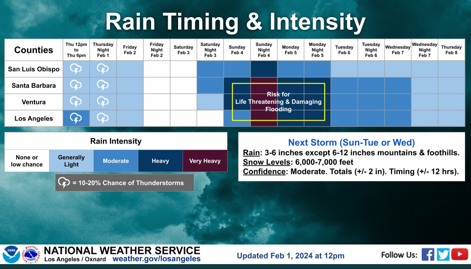
NWS RAIN FORECAST Highlights:
This storm is expected to bring 3 to 6 inches of rain countywide and 6-12 inches in the mountains and foothills.
Regional predicted totals range from:
1.66” in Cuyama to 5.72” in Santa Barbara.
Montecito could see 6.5” with up to 7.5” in the hills above.
Carpinteria could see 5.3” with up to 8.5” in the hills above.
Winds of 40-60+ MPH are expected along with large seas.

Resources and reminders to share with your school community from the OEM and NWS:
Register for countywide emergency alerts at readysbc.org.
Detailed weather forecasts are available at https://www.weather.gov/lox/.
Additional Resources:
Storm readiness tips: http://www.readysbc.org/StormReadiness
Highway updates: https://roads.dot.ca.gov/roadscell.php
County roadway updates: https://www.countyofsb.org/2116/Road-Closures
County sandbag filling locations: https://www.countyofsb.org/2219/Sandbags